Adventurers can find hidden gems and natural wonders in the off-the-grid state of New Mexico. To fully experience the state's diverse landscapes and spectacular formations, there are a ton of open spaces to discover. Many of these locations are state parks with camping, hiking, and other outdoor activity options. New Mexico's top state parks help tourists learn more about the Land of Enchantment. However, if they have to choose only one, Bottomless Lakes State Park is the place to go for bottomless fun, and it is only 14 miles (22.5 km) southeast of the intriguing Roswell. There, they can enjoy kayaking or canoeing, camping, fishing, picnicking, swimming, hiking, watching birds, or even scuba diving! Here is why Bottomless Lakes State Park is so unique.

A Brief About Bottomless Lakes State Park
On the eastern rim of the Pecos River valley is where tourists will find this magical park. Bottomless Lakes State Park's unusual lakes are sinkholes that are between 17 and 90 feet (5 to 27.5 meters) deep. The lakes appear to be quite deep because of the greenish-blue tint that aquatic vegetation produces, making this park more splendid. Nine sinkholes form the magnificent park.

Learn About Bottomless Lakes State Park's Sinkholes And Lakes
Have A Look At The Legends Of Dimmitt Lake
Dimmitt Lake, the park's southernmost lake, is owned by the Fin and Feather Club. According to legend, the lakes got their name from cowboys who were unable to locate the bottom of them. To try to reach the bottom, they would knot 2 or 3 ropes together and drop them into the lakes. The vaqueros believed the lakes had no bottom because the ropes were too short. Algae and other beautiful aquatic plants gave the water a greenish-blue hue that furthered the impression of depth. Other legends and tall stories abound as well. A horse drowned after falling into one of the Figure Eight lakes, according to one story, and was rescued from the other. Numerous items are said to have fallen into the lakes and later been found in the Gulf of Mexico or Carlsbad Caverns. Another tale is about the powerful subterranean currents that sucked swimmers and divers far into the Earth's interior, to be never seen again. People believed that each lake has its own monster, and the monsters of the Bottomless Lakes are mythical enormous turtles that hide in murky, deep depths.
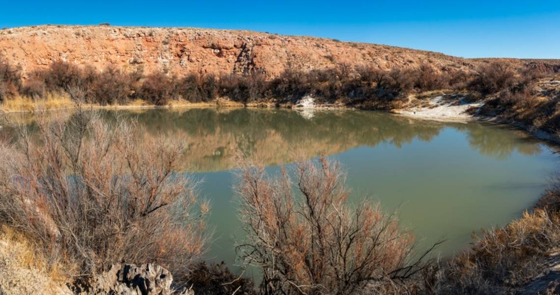
Check The Largest Lake In Bottomless Lakes State Park
The largest and most northern lake, Lazy Lagoon, also known as Intermittent or No Name Lake, has a water surface area of around 26.1 acres (10.5 hectares). It appears to be shallow, yet it may reach depths of between 70 and 90 feet (21 and 27.5 meters). The lake's white salt flats are really vast layers of foul-smelling alkaline muck covered by thin gypsum crusts. Three sinkholes combine to produce Lazy Lagoon. Except for the sinkholes, the lake evaporates significantly in the summer. Lazy Lagoon is situated along the Pecos River's abandoned channel.

Stop By The Visitor Center When Going To Cottonwood Lake
South of Lazy Lagoon, in front of Cottonwood Lake, is where tourists will find the visitor center. Cottonwood Lake has a 0.52-acre (0.21-hectare) surface area and is 30 feet (9 meters) deep. A large cottonwood tree that previously flourished on the coast inspired the name of the place. The lake's surface is surrounded by nearly vertical rock walls, and the sides have little vegetation growing on them. Rainbow trout and channel catfish are supplied in the lake.
Swim At Lea Lake
Lea Lake is home to the majority of the constructed amenities, and it is the most popular lake in Bottomless Lakes State Park. It bears the name of Captain Joseph C. Lea, a rancher, Civil War hero, and pioneer resident of Roswell. During the Civil War, Lea traveled with Clark Quantrill, Frank and Jesse James, and Billy the Kid's buddy William Bonney. The lake is formed by three sinkholes. A viewpoint on a mesa gives visitors a birds-eye perspective of the park.

Hike To Mirror Lake
A hiking route passes through the dry sinkhole known as Lake-in-the-Making on the way to a picturesque vista of Mirror Lake from Cottonwood Lake. Mirror Lake has a depth of 50 feet (15.2 meters) and a surface size of 3.44 acres (1.39 hectares). The lake's name is derived from reflections of the nearby red rocks. Mirror Lake used to be two ponds divided by a little area of land. For fish, the northern pond was excessively salty, but not the southern pond. Today, the ponds combine to form a single lake that can sustain fish. Three sinkholes created Mirror Lake.
Stop By The Smallest Of The Lakes
The smallest of the lakes, Devil's Inkwell, earned its moniker from its steep sides and inky waters, which were caused by the growth of numerous aquatic plants and algae along the lake's bottom. It has a surface size of 0.36 acres (0.15 hectares) and is 32 feet (9.75 meters) deep. In the winter, rainbow trout are supplied.
Contemplate The Beauty Of Figure Eight Lake
Figure Eight Lake, which is actually two independent lakes created by two sinkholes, is located south of Devil's Inkwell. The area between the lakes was once completely submerged, and when combined, they created the shape of an eight. The northern lake is 1.46 acres (0.59 hectares) and is 37 feet (11.2 meters) deep, whereas the southern lake measures 0.76 acres (0.3 hectares) and is 22 feet (6.7 meters) deep. Both lakes are surrounded by salt cedars.

Explore The shallowest lake at Bottomless Lakes State Park
The shallowest lake at Bottomless Lakes State Park is called Pasture Lake, and it is located south of Figure Eight Lake. It has a 0.76-acre (0.3-hectare) surface area and is 18 feet (5.5 meters) deep. The name's origin is unknown. However, some claim that it was given because of a sizable flock of ducks that previously called this area home and gave the impression that it was a pasture.
Walk To The Ninth Sinkhole
In between Picnic Dell and Lea Lake, Lost Lake may be discovered tucked away along the cliff. It is tiny, and the only way to get to it is by trekking. It is good to note that Picnic Dell is located south of Pasture Lake, and it is a dry sinkhole.