Quick Links
The hike to Pharaoh Mountain is a stamina-commanding 6.25-mile deep into the Pharaoh Lake Wilderness - a 46,283-acre region full of lakes, mountains, hiking trails, and gorgeous wildlife. Located in the central Adirondack Mountains, this stunning yet challenging trail goes through a wonderful public Forest Preserve in the remote Pharaoh Mountain Wilderness Area, which leads hikers to the summit of the famed Pharaoh Mountain.
Winding along old dirt roads, open wetlands, and the picturesque Pharaoh Lake, the scenery to soak up on this route is as diverse as it is beautiful, and since there are numerous campsites and lean-tos along the trail, camping adds itself to the itinerary, too. At 2,556 feet in height, Pharaoh Mountain isn't the most difficult nor the highest hike in the Adirondacks in terms of elevation; however, it's said to be one of the most scenic, especially the sublime vistas from the wide-open summit, which are said to be at their most breathtaking during fall's fiery foliage hues.
As with most hiking spots in this area, walkers can approach Pharaoh Mountain's peak from numerous directions. To add confusion to ample choice, it can also be accessed from at least 11 parking areas, which is perfect for people who with a penchant for exploration but baffling for beginners and first-time trail-goers. Out of the many options, the Crane Pond Trail and the Pharaoh Lake Trail are the most popular; both lead to the mountain's summit, but they're different from one another. Worry not, though; this handy guide will offer instructions on how to hike to Pharaoh Mountain via the two trails.
About This Hike
Pharaoh Mountain Trail Length: 6.25 miles (12.5 miles round trip)
Difficulty: Challenging (best suited to intermediate hikers)
The Best Time To Hike Pharaoh Mountain
The trail offers a wonderful hiking adventure year-round; the warmer months see welcoming temperatures and lush green forests blanketing the landscapes, while winter invites chillier treks amid crisp scenery - not to mention skiing and snowshoeing in the cold season. However, it's fall when this trail truly transforms itself, a time in which the deep oranges, yellows, reds, and browns of nature blend with the turning shades of green, illuminating the golden foliage in all its rich hues.
Around the fourth week of September through the second week of October, the forest canopy of maples and birches ignites into a fiery palette of oranges, reds, and bright yellows - the most spectacular samples being the half-mile corridor of gold, imposing maples at mile 1.5.
Furthermore, those camping overnight get to savor an additional experience; the sun's first rays hit Pharaoh’s forested east face, creating low-lying fog right below the bright orange hues of nature. Adding to the autumnal season's beautiful but eerie aura, coyotes in these parts don't howl; they bark, their dog-like sounds normally audible around dusk. Interestingly, experts believe these canines - which are also 10 lbs heavier than average - could actually be hybrids of western coyotes and eastern wolves.
How To Hike the Pharaoh Lake Trail
As mentioned, the two most popular ways to reach Pharaoh Mountain's summit are via the Pharaoh Lake Trail and the Crane Pond Trail. First, let's begin with the former, which to reach requires heading to the Pharaoh Lake Road parking area.
How To Get To Pharaoh Lake Road Parking Area:
From downtown Schroon Lake, trail-goers can follow Route 9 north before turning right on Alder Meadow Road. Next, they take another right turn on Adirondack Road, which they follow for around eight and a half miles until reaching Johnson Road, onto which they turn left (this road is also County Route 15).
Visitors should then follow Johnson Road for a little over two miles, then take a left on Beaver Pond Road, following that for approximately three miles to Pharaoh Road. Here, they should turn left onto Pharaoh Road and follow it for around half a mile to reach the parking area. The trailhead register is located at the edge of the parking area.
How To Hike The Pharaoh Mountain Trail
From the parking lot, the trail sets off on a rugged and muddy road, but this is only short; it soon ends at a second parking area after less than a mile. As this is a designated wilderness area, the road is gated, and no motor vehicles are permitted to drive it, except in cases of public emergency. After this second parking area, the route leads hikers through a pretty wetland meadow along a boardwalk trail.
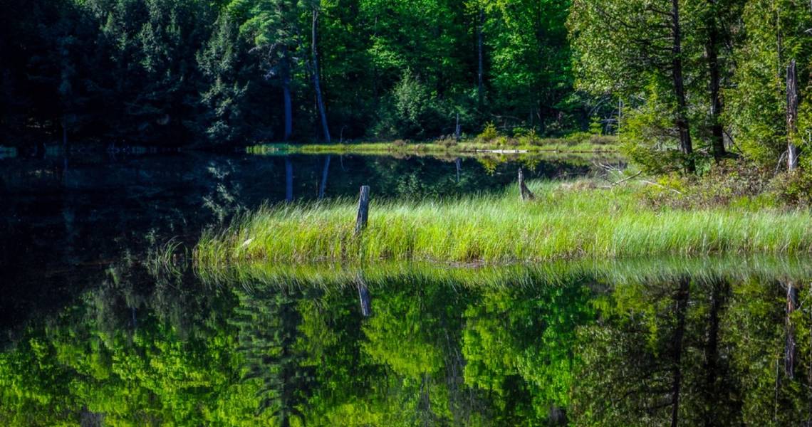
Beyond the wetland, the hike is wide and easy to navigate, its width and flat terrain making it a popular attraction in the winter for skiers. Shortly, explorers come across a bridge that crosses the outlet of an even more expansive wetland surrounding the Pharaoh Lake Brook, which parallels the route along its second section. For the most part, the trail in this second section also remains wide-open, flat, and easy. Plus, people can scope out views of Pharaoh Mountain across the wetland as they go.
Soon, hikers reach the south end of Pharaoh Lake, where they come across a trail junction. This 441-acre lake isn't just a pretty picture and natural masterpiece of the illustrious six-mile loop; it's also a superb spot to camp. For the best camping experience, campers should stay on a clear night when the Milky Way puts on a spectacular cosmic show in the dark over the lake.
Once hikers are ready to tackle the next part of the trail, they can follow the trail signs on the west shore of Pharaoh Lake, which point to Pharaoh Mountain. The forest in this section of the hike boasts lots of fiery conifers in the fall, whose colors turn after summer, although hardwoods appear later on as explorers move further from the lake. Plus, several side trails along this portion of the route lead to lakeside lean-tos and campsites on its shoreline, some of which are beautifully located on small peninsulas.
The Summit Of Pharaoh Mountain
Around half a mile along the lake's west shore, the trail up to Pharaoh Mountain turns left to the west. Hikers then climb through a beech and maple forest, which is notably steep in some parts and isn't heavily trodden; however, it's well-marked and fairly simple to follow. As the trail gets closer to the mountain's summit, conifers appear again, their shades evergreen in summer but fire-hued in fall.
Upon reaching the summit, hikers are rewarded with wide-open, sweeping panoramas in all directions, comprising Pharaoh Lake, Putnam Pond, Crane Pond, and the High Peaks out in the distance. Handily, the way back from the summit is the same; hikers can traverse the trail in reverse to go back to the start.
How To Hike To Pharaoh Mountain Via The Crane Pond Trail
Instead of taking the Pharaoh Lake Trail from the south, Pharaoh Mountain is also accessible from the equally popular Crane Pond Trail. Firstly, visitors will need to reach the Crane Pond parking area. To do so, they can take Exit 28 off of Interstate 87 and follow Route 9 southbound towards Schroon Lake. After around half a mile, they should then turn left onto Alder Meadow Road and follow it for approximately 2.2 miles.
Next, they need to turn onto Crane Pond Road and follow it for about 1.5 miles until they arrive at the large parking area right at the end of the road. Hiking the Crane Pond Trail is relatively easy, commanding a 1.7-mile jaunt to a lovely pond with plenty of sights along the way. The initial part of the path is a dirt road, though it's not recommended to drive it since it's not properly maintained. Still, the hike is well worth the effort; the views of the ravine and waterfalls at Alder Creek are a real treat.
Here's a list of directions for those who prefer to hike the Crane Pond Trail to Pharaoh Mountain:
- Follow the Crane Pond Trail south for around half a mile to the start of the loop.
- Veer left to hike the trail clockwise.
- Reach Pharaoh Lake’s north shore after around 3.2 miles
- Merge onto the Long Swing Trail, continuing 1.4 miles east and south. There'll be a lean-to here for any tired hikers.
- Walk along the shoreline for about 1.7 miles to the fork at the southern tip of the lake.
- Next, turn east onto the West Shore Trail and trek 1.3 miles to reach the Pharaoh Mountain Trail.
- Ascend 1,300 feet to the summit of Pharaoh Mountain
- Finally, hikers can continue 2.5 miles north to the trailhead
Both trails are exceptionally beautiful and offer slightly different experiences, which makes the perfect excuse to try them both to savor two unique hikes. As one of the prettiest hikes in New York State, the journey to Pharaoh Mountain is a bucket-list-worthy item, especially in fall when the lush maples, conifers, and the entire forested landscape evolves into a rich spectacle of golds, yellows, reds, and browns. When fall's sunlight graces this terrain, it sets it on fire with colors, creating one of the most scenic hikes in the state at the turning of the season.