Read update
- It's Best To Come And See The Blue Ridge Parkway And Skyline Drive During The Warmer Seasons
Quick Links
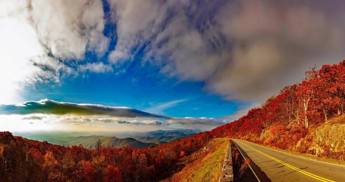
The Blue Ridge Mountains are a spectacular demonstration of how beautiful a mountain range can truly be. Rolling through the southern states of Virginia and North Carolina, these mountains earned their name due to their hazy blue appearance at dawn and dusk. It's easy to see why they've become such a popular tourist destination, especially in Virginia, where travelers taking a road trip have a choice of two scenic roads to choose from.
Both the Blue Ridge Parkway and Skyline Drive offer incredible views of the mountains as both roads navigate their most scenic peaks. While the drive down both is somewhat harrowing (even more so for one of them), they've kept roadtrippers coming back each season to see the changing scenery.
So, which road offers the better Blue Ridge views? Let's find out below!
UPDATE: 2023/09/20 20:44 EST BY NOAH STAATS
It's Best To Come And See The Blue Ridge Parkway And Skyline Drive During The Warmer Seasons
This article has been refreshed with new information regarding the best time to drive both routes, as well as tips for staying safe in the winter. Snow and ice can cause roadways to be closed during the winter months, so keep a close eye on advisories and signage. Have fun!
Blue Ridge Parkway: Distance, Location, And Views

The Blue Ridge Parkway is the longest linear parkway in the country and spans from Shenandoah Valley, Virginia, to the Great Smoky Mountains National Park in North Carolina. It runs for a total distance of 469 miles through both mountain ranges, remaining mostly on the upper ridgeline of the Blue Ridge Mountains. This parkway has also been the most visited of any national park except the year 1946. While the parkway does turn into Skyline Drive through a portion of Virginia, the Blue Ridge offers many sights that the latter doesn't - including access to North Carolina's scenery.
The Multi-Day Blue Ridge Parkway Drive
The great thing about taking the Blue Ridge Parkway is that roadtrippers can turn it into a multi-day trip. The trip can be broken down into as little as three days or as many as five to six, depending on how much time a person wishes to spend sightseeing.
The Blue Ridge Parkway tourism site recommends a road trip itinerary such as this:
- Day One: Afton, mile point 0 to Roanoake, mile point 120 ~ 3.5 hours driving time
- Day Two: Roanoake to Fancy Gap, mile point 199 ~ 2.5 hours driving time
- Day Three: Fancy Gap to Blowing Rock, mile point 293 ~ 3 hours driving time
- Day Four: Blue Rock to Asheville, mile point 382 ~ 3 hours driving time
- Day Five: Asheville to Cherokee, mile point 469 ~ 3 hours driving time
The trip back the same way will only take two to three days, so this is the perfect week-long trip to plan for serious road trippers wishing to see all the Blue Ridge Parkway's beauty. Additionally, there's no toll or fee to get on and off the parkway, which makes it very budget-friendly, as well!
Why Consider the Blue Ridge Parkway?
Those driving along the parkway will also be happy to know that it's not necessary to stop at an overlook in order to enjoy the surrounding scenery. The road is a little more beginner-friendly than Skyline Drive and permits full views at any given time during the drive. Additionally, it's biker-friendly and offers the chance for travelers to camp, hike, travel via RV, and pull off into smaller towns along the way.
Skyline Drive: Distance, Location, And Views

Visit Skyline Drive describes the experience as 'epic,' and anyone who has traveled this road would be inclined to agree. If mountain switchbacks and great-height views are something of interest, then this road is the way to see them. In stark contrast to the Blue Ridge Parkway, Skyline Drive is only a fourth of the length, with 105 miles of roadway to drive. This means that it's an easy day trip - even from one end to the other - for those who are staying in Virginia's Shenandoah Valley.
The four main entrances to the mountain road are as follows:
- Front Royal Entrance Station, mile marker 0 at Rt. 66 and 340 in Front Royal, Virginia
- Thornton Gap Entrance Station, mile marker 31.5 at Rt. 211 near Luray, Virginia
- Swift Run Gap Entrance, mile marker 66.5 at Rt. 33 near Elkton, Virginia
- Rockfish Gap Entrance Station, mile 104.6 at Rt. 64 and Rt. 250
*Note: The national park site also recommends following these directions to each entrance, as the GPS can sometimes be incorrect.
Why Consider Skyline Drive?
Skyline Drive is great for day trips, and the average speed limit along most of the road is 35 miles per hour. This is due to the switchbacks that take drivers through the mountains, which can often include blind turns and narrow sections of the road. Also known as the 'Gateway to Shenandoah,' this road is flanked by stone walls that serve as guardrails, over which travelers will have breathtaking views of the mountains.
There are also plenty of overlooks to be found along Skyline Drive, which allows drivers to safely pull over for photo ops or just to take in the beauty surrounding them. Skyline Drive is also part of Shenandoah National Park, which means it provides access to wooded hiking trails, some of which lead to Blue Ridge Mountain summits. Those interested in getting out and exploring the Blue Ridge Mountains of Virginia on foot will be more than happy to take this winding road up to its ridgeline and will be rewarded with some of the most scenic hikes in the state.
Other Factors To Consider When Choosing Between The Blue Ridge Parkway And Skyline Drive

- The Blue Ridge Parkway is longer than Skyline Drive.
- Both trips are beautiful, although the weather can make The Blue Ridge Parkway more challenging.
One thing that many people don't consider before choosing between these two scenic routes is the weather, along with other outside factors that could affect their trip. Since the Blue Ridge Parkway is longer and offers more options for travelers depending on where they're getting on and off, it's more accessible overall throughout the year.
Skyline Drive is a more extreme roadway that's incredibly beautiful but is also shorter, meaning there's a shorter window of time when travelers can take it without worrying about significant hazards via weather or vehicular accidents. Therefore, the time of the year - and the road conditions - should also be taken into consideration when planning a trip to either one of these scenic roads.
So, Which Road Is More Scenic?

- Skyline Drive is often regarded as the more scenic choice in a short period.
- Blue Ridge Parkway is also very beautiful, although it takes longer to navigate.
Arguably, Skyline Drive offers views that reward the courageous driver. Its hairpin turns, and switchback length runs straight down the ridgeline of Virginia's Blue Ridge, with dramatic views of the outlying mountain range.
The Blue Ridge Parkway does offer similar views but includes those of North Carolina's mountains - therefore, it's a two-for-one deal that comes with a multi-day trip. There's also more to do along the way of the Blue Ridge, whereas Skyline Drive offers solid views and great national park hiking access.
Key Highlights On The Parkways To Mark On The Map

Not all the worthwhile highlights along the two routes will necessarily be noticeable while driving along the two parkways. So take the time to do a little research before heading out and dropping some pins on one's Google Maps.
Some of the notable attractions along the Blue Ridge Parkway include:
- Mabry Mill: Milepost 176, One Of The Most Pictured Sites Of the Route, It's A Stunning 1900s Wooden Gristmill
- Cascade Falls: Milepost 272, Only A Mile Hike to The Thunderous Waterfall
- Rough Ridge: Milepost 303, See The Famous "Lion King Rock" Overhanging 4,700 Feet
- Chestoa View Overlook: Milepost 320, One Of The Best But Easiest To Miss Overlooks Of The Parkway
- Waterrock Knob: Milepost 451, Just 18 miles From The End Of The Parkway, Offers Views Fit For A Finale
Some of the notable attractions to have pinned on the map of Skyline Drive include:
- Mary's Rock Tunnel: Milepost 32, Stop And Take A Pic With The Historic 1932 Tunnel
- Moormans River Overlook: One Of The Peaceful Looks Of The Drive With Lush Forest
- Stone May Mountain Overlook: Milepost 38, Offers Panoramic Views Of The Valley With Massanutten Mountain In The Distance
- Baldface Mountain Overlook: One Of The Most Scenic Overlooks Of The Drive
These are just a few of the many points of interest dotted all along the two parkways and drives. Take the time to drive both of them and enjoy both of them at different times of the year. Another great and historic parkway to take the time to explore in the USA is the Natchez Trace Parkway.
What Is The Best To Drive The Blue Ridge Parkway And Skyline Drive?

- The spring, summer, and fall are the best times to drive the Blue Ridge Parkway and Skyline Drive.
- Winters can be harsh in this area, bringing road closures to both routes.
Because Skyline Drive runs the length of Shenandoah National Park and connects with the northern end of the Blue Ridge Parkway, this makes a dual road trip even more enticing. Weather-wise, this route is best done during the spring, summer, and fall before the winter kicks in. During colder months, it's not uncommon for snowfall and icy conditions to impact drivers along both these roadways: which isn't always safe to go through. Furthermore, sections of the various parks people pass through on the Blue Ridge Parkway and Skyline Drive will likely be closed off during November, December, and January, when snowfall is heaviest.
During the winter, sections along the Blue Ridge Parkway and Skyline Drive can become closed due to inclement weather. Keep an eye on closures and avoid bypassing signage and other obstructions sectioning off closed portions of these roads.
Those driving in larger all-terrain vehicles may not be affected by snow and ice, so consider renting a larger, more capable car before venturing off. The Shenandoah National Park is one of the most popular stops during Skyline Drive, and the park mentions it is periodically closed during inclement weather. However, hikers can still get through the park on foot during snow/ice. Onto the Blue Ridge Parkway, snow and ice may also cause road closures, so this can become a problem either way.
It's also worth mentioning that in the summer, both drives will see more traffic and people, which could mean congestion around park entrances and exits. Try and follow all posted signs and stay vigilant behind the wheel to prevent car accidents. Besides steep winding hills, both drives can become even trickier to navigate under harsh rain, snow, ice, and even wind.