Read update
- There Are Two New Hikes To Try In The Golden State!
Summary
- California offers a plethora of majestic backpacking trails, ranging from easy to challenging, with breathtaking views of untouched land.
- The article provides a list of the best backpacking trails in California suitable for both amateurs and experienced hikers.
- Each trail has its own unique features and challenges, so hikers should be prepared with the right gear and knowledge before embarking on their adventure.
With over 15 million acres of wilderness that comprise about 15 percent of the state, California has a lot in store for the outdoorsy. The numerous stunning national parks, forests with tall trees, state parks, and other rugged terrains make for a plethora of majestic backpacking trails, ranging from easy to challenging. So hikers can choose one that is leisurely or strenuous, depending on their experience. But one thing they all promise is breathtaking views of untouched land.
However, choosing the best backpacking trails among thousands of contenders can be nerve-wracking. This list compiles the best backpacking trails in California that can be suitable both for amateurs and experienced hikers. Whether you are a new hiker or an experienced one, there's a trail in California!
UPDATE: 2023/10/06 12:52 EST BY NOAH STAATS
There Are Two New Hikes To Try In The Golden State!
This article has been refreshed with two additional hiking trails in the Golden State, as well as tips for those heading out. Whether it's a trail overlooking Los Angeles, rock climbing in San Diego, or somewhere more remote, California offers amazing hiking to its residents and visitors. Have fun!
16 Runyon Canyon

For those in the Los Angeles area wanting to hike, Runyon Canyon is a fun, intermediate-level hike to consider trying. Here lie the various trails, including 1.9 miles, 2.65 miles, 3.3 miles, and longer are all possible From the North Fuller Avenue Trailhead for Runyon Canyon Park. This has become one of the more famous options in LA County, with influencers, A-listers, and everyday citizens of the area coming to breathe fresh air. The views alone make Runyon Canyon a must-do for those wanting to get active on their trip to the City of Angels. It might also be best to start small and work your way up to an advanced trail here, especially as a newer hiker.
- Location: Los Angeles
- Length: 2.7 miles
15 Climbers Loop Trail

If someone is in the Bay Area looking to hike, Climbers Loop Trail is a can't-miss opportunity. Here, people will enjoy the 1.8-mile loop trail near San Diego, California. Generally considered a challenging route, there will be rocks, inclines, and steep sections of this hike, making it a bit more adventurous. However, it's only 15 minutes from downtown, which is why so many locals and tourists hit the ground here each day. Climbers Loop is meant for rock climbers mainly, so that's another detail to consider before making the drive over.
- Location: San Diego
- Length: 1.8 miles
Although this trail is usually busy with other hikers and climbers, it is highly recommended to bring a partner. As this is rock climbing, the chance of injury is far greater for solo travelers. Stay safe, and try to have a charged phone, water, rescue kit, and snacks.
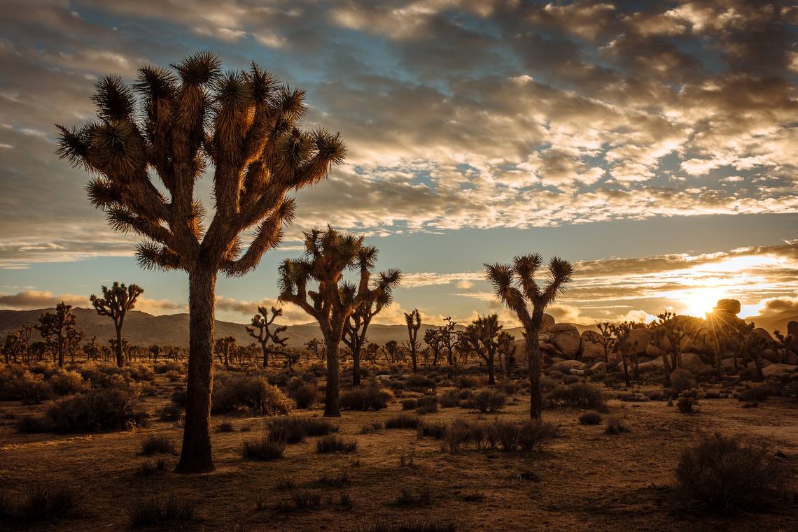
14 Boy Scout Trail Joshua Tree

The 8-mile rocky Boy Scout Trail starts from the Keys West Backcountry Registration parking area and ends near the Indian Cove Campground. The first three miles involve trekking along the Mojave Desert landscape and moving toward the Wonderland of Rocks. At this point, it is advisable to find a camping site since it's hard to find a flat space past this area. After a long rocky descent through the canyon, backpackers enjoy beautiful vistas before the trail makes its way to Indian Cove.
- Location: Joshua Tree National Park
- Length: 8 miles
Hikers should be prepared for an early sunset and cold nights if they are camping during the off-season.
13 Pacific Crest Trail-Campo To Warner Springs

The Campo to Warner Springs section of the Pacific Crest Trail runs for approximately 104 miles. The hike starts from southern Campo to Hauser Creek, where it is wise to take on the daunting climb in the evening. From Hauser Creek, travelers go to Lake Morena County Park and the pine-forested Mount Laguna. The trail continues meandering to Julian, Scissors Crossing, Barrel Springs, the famed Eagle Rock, and Warner Springs.
While in Warner Springs, adventurers can camp, go shopping for essentials at the mini-mart, or resupply if they want to continue with the adventure.
- Location: Pacific Crest National Scenic Trail
- Length: 104 miles
12 Duck Lake Pass Trail

Duck Lake Pass Trail starts with switchbacks and stretches along Skelton Lake. From this lake, adventurers head to Barney Lake, sitting at the base of Duck Pass, and find camping spaces at the eastern fork of the lake.
After an overnight camping experience, visitors wake up to a stunning sunrise and majestic reflections of snow-capped mountains in the still waters. The ascent to Duck Pass provides vistas of far-off mountains and the lake basin below. Once the pass is over, adventurers see the impressive Duck Lake surrounded by peaky mountains.
- Location: Inyo National Forest
- Length: 10 miles
11 Buckeye Trail

Buckeye Trail is an out-and-back 12.6-mile track near San Simeon in California. The first few miles are exhausting with little shade cover. But this can be made effortless if travelers start this adventure earlier in the morning when the temperatures are cool. Since most creeks along the trail are dry, hikers should bring enough water to get them to Villa Creek during dry seasons. As backpackers descend to Villa Creek, they marvel at the gorgeous redwoods and gushing creek.
- Location: Los Padres National Forest
- Length: 12.6 miles
Backpackers should wear long pants, carry insect/bug repellents, and beware of poison oak.
10 South Fork Trail

The South Fork Trail is a 21.3-mile loop trail that leads adventurers to San Gorgonio Mountain. This trail is completed in two to three days while travelers acclimatize and camp at Lodgepole, Dry Lake, or Trail Flat. Adventurers can find water at the seasonal creeks and at the Lodgepole Spring.
South Fork Trail is challenging because of the changing altitude, backpack weight, high winds, and rugged terrain. However, the expansive meadows and panoramic views from San Gorgonio Mountain make up for the challenging trek.
- Location: San Bernardino National Forest
- Length: 21.3 miles
9 Trans-Catalina Trail

The mountainous terrain and breathtaking ocean views make the 38.5-mile Trans-Catalina Trail a once-in-a-lifetime backpacking experience. Many adventurers break the hike into five sections that take at least five days to complete. They start from Avalon to Black Jack to Little Harbor to Two Harbors and finally to Parsons Landing. All these points have designated campgrounds with diverse but incredible views for travelers to admire as they set their camps.
- Location: Catalina Island
- Length: 38.5 miles
Although the Trans-Catalina trail is open year-round, the best time to take on this intriguing adventure is late winter or spring.
8 Half Dome Trail

Backpackers fulfill their goal of hiking from Yosemite Valley to the Half Dome summit through a strenuous 14-15 mile trail. While hiking, travelers see incredible sights, like Vernal Falls, Emerald Pool, and the Nevada Waterfall. A three-day backpacking trip is enough for adventurers to immerse themselves in the awe-inspiring nature of Yosemite Valley. They can also spend the night at Yosemite Valley Lodge, which offers dramatic views of the area.
The final journey to the Half Dome summit involves ascending a steep and exposed section of the trail by holding on to steel handrails. Once at the top, hikers revel in the Buena Vista Crest, Sawtooth Ridge, and Mount Maclure's astounding views.
- Location: Yosemite National Park
- Length: 15 miles
7 John Muir Trail

The John Muir Trail travels 210 miles from Yosemite National Park to the 14er Mount Whitney. It passes through notable attractions like the Sierra Mountains, Ansel Adams Wilderness, and the spectacular King's Canyon Park, among others. Most adventurers take around three weeks to traverse these attractions.
Since this is a strenuous and long backpacking hike, only advanced backpackers should undertake it from July through October, depending on the weather. Despite the trail's daunting nature, adventurers see the unobstructed lake and mountain views and have mind-blowing stargazing experiences.
- Location: Yosemite National Park
- Length: 210 miles
6 Mount Whitney Trail

This 11-mile trail takes adventurers to the tallest 14er in California, which is Mount Whitney. The route takes about three to four days to complete. Travelers begin their journey at the Whitney Portal, then to the Consultation Lake, reach the peak, go back to the lake, and then to Whitney Portal again.
There are three campgrounds for adventurers, but the Trail Camp is the most popular. Camping under the starry nights makes the whole adventure worth it. However, when setting up a tent, one should select an existing site to avoid damaging the area by creating a new one.
- Location: Inyo National Forest
- Length: 11 miles
5 Lost Coast Trail

The 24.6-mile Lost Coast Trail starts from Mattole Beach, leading adventurers to Black Sands Beach, stretching along the undeveloped Long Coast shores. Although it is tough for travelers to get permits to travel along this coast, they can camp anywhere with public access. The trail is not hilly but has sandy and rocky beaches. This point-to-point trail takes about three days to complete, giving backpackers enough time to stop and admire the magnificent coast.
- Location: King Range National Conservation Area
- Length: 24.6 miles
It's advisable to check the tide levels and weather since they may change drastically.
4 Crystal Cove Perimeter Loop

Southern California offers breathtaking trails with views that gaze upon the Pacific Ocean's deep blue waters, and the whole shore surrounding Crystal Cove is a prime example of that. Although most people don't really have in mind backpacking on California's beaches, the Crystal Cove Perimeter Loop takes hikers through an 18-mile trail throughout the area's most scenic locations, like Lower Moro, Upper Moro, and Deer Canyon.
- Location: Crystal Cove State Park
- Length: 18 miles
3 Marion Mountain Trail To San Jacinto Peak

Called "the most sublime spectacle to be found anywhere on this earth" by ecological thinker John Muir, the San Jacinto Peak is truly one of California's most magnificent natural marvels.
Leaving from the Marion Mountain Campground, the trail follows 11.4 miles through the tree-filled scenery of California's countryside, with the possibility of gazing upon the region's both flora and fauna. This might be one of the most challenging trails to get up to San Jacinto, but it can also be one of the most rewarding given the variety of sceneries the route goes through.
- Location: San Bernardino National Forest
- Length: 11.4 miles

10 Most Beautiful Waterfall Hikes Around The World
These waterfall hikes are not just beautiful but incredibly refreshing.2 Devil's Punchbowl Trail

Don't be put off by the quirky name; this challenging trail is a must for people who prefer rocky walks rather than flat strolls. The hike does a great job of showcasing the Six Rivers National Forest's changing terrain and offers easy access to the park's main water features, such as the Smith River. It's also a plus that the trail is welcoming to dogs, as long as they're on a leash.
- Location: Six Rivers National Forest
- Length: 10 miles
1 Lassen Peak Hike

Feeling more adventurous? Then climbing one of Lassen Volcanic National Park's most scenic peaks is the ideal plan. Going up the way to Lassen Peak, the 5-mile-long climb is not for the unprepared since volcanic activity from thousands of years ago and rocks falling from above make for a rather unstable path filled with pieces of rocks that require special gear to maintain balance. Once up, the reward is being able to glance at all the park's plenitude, as well as its many lakes that serve as a break from the trees and volcanic land.
- Location: Lassen Volcanic National Park
- Length: 5 miles
If backpacking around the land, avoid packing too heavily before heading up the peak.