Mother Nature has given our world vast wonders like the stunning Cliffs of Moher in Iceland, to the emerald waters and limestone towering islands of Ha Long Bay in Vietnam and the magnificent sea cliffs and cascading waterfalls in Na Pail Coast Wilderness Park in Hawaii, just to name a few. With all of the beauty on our planet that Mother Nature has given us, we should remember that sometimes she could take it all away in the blink of an eye.
This source and guiding force of creation can also be extremely powerful, with the means to destroy anything in her path. We've seen tragedy strike in just about every part of our earth whether it's by forceful winds, devastating hurricanes, volcanic eruptions, damaging tornadoes or catastrophic earthquakes. Mother Nature has provided our earth with stunning beauty, however, she also has the immense strength to literally move our planet and create conditions no one can control.
The United States and Canada have witnessed extreme conditions thanks to Mother Nature that have left places unrecognizable. During these intimidating times, we either leave or brace ourselves for the worst. Here we've listed twenty photos of Mother Nature blazing through the United States and five photos from Canada that will show how fatal strong she can really be.
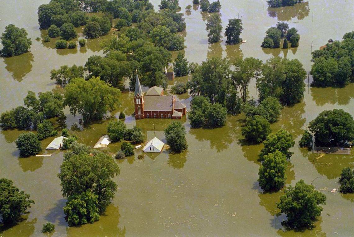
23 The Great Flood Of 1993

One of the most costly floods in the United States was called The Great Flood of 1993 when over a three-month-long period in the summer of that year, a slow-moving flood spread across the Midwestern U.S. and destroying anything and everything in its way. According to Accuweather, over 17 million acres were flooded, a majority of it being farmland. The impacts of the flood lasted for years, devastating states including, North Dakota, South Dakota, Nebraska, Kansas, Minnesota, Iowa, Missouri, Wisconsin, and Illinois. The flood destroyed around 50,000 homes and 75 towns were totally under floodwaters. It was estimated that the damages cost the United States a whopping $15 billion.
22 California's Earthquakes Are Unrelenting

In the United States, California places second after Alaska with having the most earthquakes in a given year. One of the most damaging earthquakes in California was called The Great San Francisco Earthquake of 1906, which struck San Francisco and the coast of northern California. It was a 7.8 magnitude earthquake that was even felt from Oregon to Los Angeles, and inland as far as central Nevada. The earthquake ruptured the San Andreas Fault both northward and southward for a whopping total length of 296 miles. According to Central National, 225,000 to 300,000 people were left homeless out of a population of 400,000 and over 80% of the city was destroyed.
21 Earthquakes Occur Most Often In Alaska

Most earthquakes occur in Alaska where there are an astonishing 24,000 earthquakes a year, according to the U.S. Seismology Department. There are so many earthquakes in the 49th state because it is in a place where two major tectonic plates, one continental and the other oceanic bump into one another quite a few times. According to Alaska Kids, on average, every thirteen years, Alaska has an earthquake measuring at least 8.0 on the Richter scale. The second largest earthquake in the world was reported in Alaska. Called the Good Friday Earthquake, it struck the state on March 27, 1964, at a 9.2 on the Richter scale. The quake reportedly was so strong; it released ten million times more energy than the atomic bomb that destroyed Hiroshima during World War II.
20 Mount Kilauea In Hawaii Is One Of The Most Active Volcanoes In The World

Located in Hawaii, Mount Kilauea is one of the most active volcanoes in the world and has been deemed a very high threat for decades. In May of 2018, the volcano erupted in lower Puna, which forced thousands of people to evacuate and destroying entire communities and hundreds of homes. While the eruptions have stopped, geologists warn that Kilauea can erupt at any given time. According to USA Today, Kilauea volcano eruption is one of the biggest in recent Hawaii history, enough to fill 100,000 pools. Since its eruption, it has emitted about 250 million cubic meters of lava.
19 Thunderstorms Are Extremely Common In Florida

Thunderstorms are extremely common in Florida and they come and go so often, residents tend to ignore them and go about their day to day, however, Mother Nature can be very dangerous and people have lost their lives. According to the National Weather Service Florida tops the national list for lightning fatalities with 468 between 1959 and 2013. Thunderstorms become severe when they produce wind gusts of 58 or more miles per hour and large amounts of rain, hail, and lightning. The combination of lightning and rain can cause damage from fires to flash flooding. So make sure to take precaution and listen to weather stations so that you and your family remain safe.
18 Florida Averages Over 70 Thunderstorm Days Per Year

A thunderstorm is defined as a storm that contains lighting and thunder, which are caused by unstable atmospheric conditions. The state of Florida averages over 70 thunderstorm days per year with much of the Gulf Coast experiencing 80 to 100 days a year. According to Florida Disaster.org, the state has all the ingredients needed to create thunderstorms, these things include, the atmosphere needs to be moist, unstable, and have a source of light. Florida is surrounded by water so there are plenty of sources of water vapor to feed a thunderstorm. Cities like Tampa, Orlando, M, ami and Jacksonville have the most frequent thunderstorms.
17 Winter Weather Blasts Through Michigan

Winter weather is not fun to be around if you aren't a fan of the snow and the blistering cold. Mother Nature comes in fierce for many states like Michigan, which sees ice storms, heavy snowstorms, record-breaking frigid temperatures and if you live in Michigan, winter has taught you exactly what a polar vortex can feel like. In December of 2013, it was the worst ice storm in years for southern Michigan. Between .5" and .75" of ice accumulation caused a state of emergency. The Upper Peninsula experienced its coldest winter on record with an average temperature for the entire winter of only 7.5 degrees.
16 Minnesota Has The Most Dreaded Winters In The U.S.

Minnesota wins the award for the most dreaded and miserable winters. According to Tip Hero, Minnesota gets hit with the worst mix of meteorological downfalls with winter weather patterns like Alberta clippers and Panhandle hooks common in the state, which brings constant snow. The snow can pile well over 200 inches in some areas of Minnesota and winter weather can last for five months! Also, the winter temperatures aren't so inviting either. Temperatures can usually hit -60 degrees, which means frostbite can occur in a matter of minutes. So, if you aren’t a fan of the cold, we don’t recommend moving to Minnesota anytime soon.
15 One Thousand Tornadoes Hit The U.S. A Year

The United States leads the list of tornado counts with approximately 1,000 tornadoes a year. One of the worst tornadoes to hit the U.S. was back in 1925 when it touched down about three miles northwest of Ellington, Missouri. Called the Tri-State Tornado of 1925, this devastating tornado is currently the U.S. record holder for longest tornado track (219 miles), most casualties in a single tornado, (695), and most injuries in a single tornado. The tornado crossed three states, including, Missouri, Illinois, and Indiana, and destroyed nine towns and a number of smaller areas. The tornado was especially deadly because of its speed, with the average speed of its lifespan was a whopping 62 miles per hour.
14 Missouri Faces Deadly Tornadoes

Tornadoes are deadly and Missouri would face a catastrophic EF5-rated multiple-vortex tornado in 2011. This devastating tornado struck Joplin, Missouri late in the afternoon on May 22, 2011. The tornado was part of a larger late-May tornado outbreak and reached a maximum width of about one mile during its path. What made the tornado unique was that it intensified in strength and grew larger in size at a very fast rate. The 2011 Joplin Tornado is considered the seventh-deadliest overall in the United States and caused damages amounting to $2.8 billion.
13 Mount St. Helens Erupts In Washington

On May 18, 1980, Mount St. Helens in Washington erupted, causing a colossal avalanche and ash falling as far away as Minnesota. According to History, seismic activity at the volcano began on March 16th and the first eruption occurred on March 27th, when a 250-foot wide vent opened at the top of the volcano and ash blasted through going some 10,000 feet in the air, causing static electricity and lightning bolts. Finally, on May 18th, a 5.1 magnitude earthquake and eruption occurred and ash blasted out at 650 miles per hour. Clouds of ash, rocks, gas and glacial ice came down the side of the mountain and magma flowed for miles.
12 The Great Galveston Hurricane

The Great Galveston Hurricane is known as the deadliest natural disaster in United States history. When the category four hurricane hit the city of Galveston, Texas on September 8th, 1900, it destroyed over 3,600 buildings with winds surpassing 135 miles per hour, according to History. During that time, hurricane science was not as advanced as it is now, and poor communication resulted in a death toll range of 6,000 to 12,000. The hurricane in 1900 was a lesson learned for the Weather Bureau that they desperately needed to have better communication channels to keep people safe.
11 Hurricane Katrina Hit Hard

Hurricane Katrina was one of the worst hurricanes to hit the United States. In late August 2005, a tropical cyclone hit the southern U.S. and resulted in more than 1,000 lives lost and ranked as the costliest natural disaster in the United States, according to Encyclopedia Britannica. Hurricane Katrina became extremely destructive and caused major damage from central Florida to eastern Texas. Cities from New Orleans, Louisiana to Biloxi, Mississippi saw severe flooding damage and numerous failed levees around New Orleans resulted in catastrophic flooding. The total damage of Hurricane Katrina was a staggering $125 billion.
10 California Experienced The Worst Drought On Record

Between 2011 and 2017, the state of California experienced one of the worst droughts on record. The period between 2011 and 2014 was the driest in the history of the state. A total of 102 million trees died because of the drought, with 62 million dead in 2016 alone. According to Science News, the drought is the driest period since before Charlemagne ruled the Holy Empire. By the end of 2016, 30% of California had emerged from the drought, while 40% of the state remained in the extreme drought levels. However, the winter of 2016-2017 was the wettest on record for northern California and because of the heavy precipitation, the governor declared that the drought had ended.
9 California Loses 2 Billion Dollars A Year Because Of Droughts

A drought occurs when there isn't enough rain for an extensive period of time. Droughts can be very dangerous, especially for people who live in areas where there isn't enough food and water. When there is no water, farms suffer, crops fail and not only do farmers lose money, there won't be enough food to go around, reports the BBC. According to National Geographic, the lack of precipitation causes a wide array of problems for communities, including damage to crops and a shortage of drinking water. These effects can lead to tremendous economic and social disasters, including famine, forced migration, and conflict. Since 2014, California has lost 2 billion dollars a year because of drought.
8 Chicago's 1995 Heat Wave Was Challenging

A heat wave is a very serious natural phenomenon that generally results from trapped air, which means that instead of cycling around the globe, it stays put and warmed like the inside of an oven. In 1995, Chicago, Illinois experienced a three-day heat wave that left the city quite unprepared with over 700 people losing their lives. According to Chicago Mag, the city endured the deadliest stretch of heat ever recorded in the United States. By the afternoons, the temperature rose to a staggering 104 degrees but it felt like 125 degrees, according to the heat index. A few days after, the heat wave finally moved, but cities like Pittsburgh, Pennsylvania and Danbury, Connecticut saw record high temperatures.
7 North America Experienced A Massive Heat Wave In 2011

Mother Nature does not play around when it comes to heat waves. During the summer of 2011, North America experienced a deadly heat wave that affected the Southern Plains, Midwestern United States, Eastern Canada, Northeastern U.S., and much of the Eastern Seaboard. The heat index reached an astounding 131 degrees, shattering many heat records in cities and towns. Some areas even saw more than a month of 100-degree weather temperatures and it caused water levels in reservoirs to drop to historic lows in two states. In 2012, the Western United States was plagued by wildfires after another continental heat wave struck and also resulted in a drought that devastated crops in the Midwest.
6 Numerous Wildfires Spread Through California

California experiences numerous wildfires thanks to its climate, dried brush, and Santa Ana winds. According to Reuters, during Santa Ana conditions, fires can be easily ignited by nature and once they are whipped by winds, the fires spread fast and become very hard to fight. In fact, Mother Nature came in fighting last year when California experienced its most destructive wildfire season on record. There was a total of 9,133 fires burned 1,381,405 acres, including five of the twenty most destructive wildland-urban interface fire's in the state's history, according to the California Department of Forestry and Fire Protection.
5 Canada Experiences Harsh Ice Storms

Freezing rain causes ice storms and that rain creates a film of ice that can make traveling on roads extremely dangerous. The worst ice storm in Canada occurred for six days in January 1998, when freezing rain coated Ontario, Quebec, and New Brunswick with three to four inches of ice. There were massive power outages for as along as a month after numerous trees and wires fell and utility poles and transmission towers came down. It was considered the most expensive natural disaster for Canadians. According to Environment Canada, the 1998 ice storm affected more people than any other weather occurrence in Canadian history.
4 Thousands Of Avalanches Occur Every Year In Canada

There are an average of fourteen avalanche-related deaths in Canada every year. One of the worst and most tragic avalanches in Canada occurred in 1910 when 62 men clearing a railroad line near the summit of Rogers Pass through the Selkirk Mountains in British Columbia were killed. Thousands of avalanches occur in Canada each year and they happen in all regions of the country. However, they are most frequent in the mountains of British Columbia, Yukon and Alberta. Avalanches are no joke, and they can even reach speeds of 80 miles per hour within about five seconds.